Lobster Season is OPEN

So we’re hanging with some cruisers the other day when someone casually remarks, “It’s almost the end of lobster season….”  Sabrina and I shared a look of horror.  We’ve only caught one lobster so far in the Bahamas!

We can’t return to the States defeated by a crustacean!

The upcoming end of lobster season coincides with a few things to note:

  • Our frozen meat provisions are getting low, and we are in need fish/lobster/conch
  • We’ve spent way too much time on Long Island and we need a hobby to keep us busy
  • We’re in close proximity to the Jumentos and the great spear-fishing and lobstering they provide
  • We have to hang around Long Island until we can extend our visas at the immigration office at the end of the month.

At breakfast the next morning, Sabrina and I casually decide that the BEST way to spend the next two weeks in the Long Island area (and not go completely stir crazy) would be  to  catch every lobster we can possibly find, hence “Lobster Safari” was born.  We’re going on a two week binge to exterminate every bug (lobster) we can find!  In accordance with all governing laws, catch limits, size limits, and fishing regulations.  Naturally.

Day 1, Sunday, we had a rough time snorkeling on the Atlantic side of Long Island: Lobsters = 0

Day 2, Monday – it rained, we read and slept: Lobsters = 0

Day 3, Today – we moved up to Calabash Bay on the north end of Long Island. Calabash Bay has been on our list for awhile, there’s a beautiful beach, a wifi signal, Cape Santa Maria resort, and a few coral reefs to snorkel, and snorkel we did.  The only problem with Calabash is the ocean swell tends to wrap around the point and cause the boat to roll.  We can deal with it for the reasons listed above, and fresh lobster goes a long way to cancel out the swell!  Lobsters = 2 (and I should have had a 3rd!)

The big guy is huge, and makes the other guy seem tiny, but don’t worry, he’s over the legal size of a 5-1/2 inch tail.  Tonight these two will be served with some angel hair pasta and a nice pesto sauce.  (Earlier today Sabrina informed me that we’d be having curried lentils and rice for dinner unless we caught something, that might have increased my vigorous search for dinner.)

Categories: Uncategorized | 4 Comments

Different Strokes

We’ve had a recent taste of “cruising” in the sense that a lot of other people go “cruising.”  Since we’ve been trapped in Thompson Bay with these high winds and we’ve slowed down a bit and started doing things that normally aren’t on our usual activity list.  We’ve read a lot of books, watched a few movies, the other night we went to a cruiser’s jam night, and tonight we’re headed for a happy hour on the beach (at 4:00.)

It’s not our normal snorkel/scuba/fishing/adventure experience, but it’s nice for a change of pace.  We just filled up with water and now we’re headed back to our anchorage in the north of Thompson Bay.  There’s supposed to be a weather window later this week so we’re getting things ready for a jump to the remote island chain of Crooked/Acklins.  Hopefully these “remote islands” are more remote than the supposedly remote Jumentos.  We’ll see.

Eventually we’ll find that “One Particular Harbor,” but the search is half the fun.

Categories: Uncategorized | 2 Comments

Long Island BREEZE

We arrived to Long Island before the last cold front hit so we could meet up with our friends Sean and Shannon, who were flying in on February 29th.  The local hangout for the cruisers at Salt Pond is The Long Island Breeze, and the name sums up the last 10 days perfectly…

Our good friends (and avid blog followers) Sean and Shannon signed up for the live blog feed to start on the afternoon of February 29th and we were greatly looking forward to their visit. After some difficulties with air travel (that started when their first flight from Philadelphia was cancelled) I was overjoyed when I saw them arrive at Deadman’s Cay airport on a different airline, but almost at the same time as their original flight.  We stayed on JV the first night, enjoyed some mahi tacos, and caught up.

Thursday – March 1st – Big Blue Hole

Long Island is a difficult island to explore entirely by boat. The western shore is very shallow, and the eastern shore is exposed directly to the Atlantic. On the west side, the southern half of the island is too shallow to explore by boat, but it is famous for its bonefishing. Most people opt to rent a car to see the island, and since we had to wait for winds to settle before leaving anyway, that’s what we did. We remembered to keep it on the left-hand side of the road. Fortunately, most of the traffic on Long Island comes from goats, and we were able to avoid them as well.

Thursday, we traveled to Dean’s Blue Hole, the largest blue hole in the world and host to the world free-diving championship. We each took a plunge from the cliffs into the deep blue before leaving to tour some of the settlements along Long Island.  We checked out Clarence Town on the Southeast side of the island and toured the two twin churches that are the landmark of the small settlement. We stopped at Max’s Conch Bar for lunch (fantastic), and then headed for the Columbus Monument on the north end of the island.  Finally, we wrapped up the day with a rake n’ scrape at a bar about 20 miles up the road from where the boat was anchored.

The Columbus Monument was well worth the effort we put in to get there. You have to follow a very rough road for a couple of miles in a tiny rental car, but the view from the monument was spectacular. Not to mention the many beaches and bays that you pass and can explore along the way.

Friday – March 2nd – Jumentos Bound / Water Cay

The winds were right on Friday, and we hauled the anchor to head to the Jumentos, a series of small islands to the south of Long Island that is primarily used as the route to cruise to Cuba.  These islands are known for their desolation, remoteness, and beauty.  The guidebook says that this is a true opportunity to enjoy the Bahamas without the crowds and to experience the peacefulness of a true tropical wilderness.  After reading the guidebook, it was no surprise that after a fantastic 45 mile sail we dropped the anchor near Water Cay, a three-mile long island that had 6 other boats already there….  Apparently everyone decided to seek privacy and peacefulness in the same exact place.

We headed to shore in the dinghy to explore this small barrier island, and I can see the attraction.  The water is clear, the islands are undeveloped, and there’s no sign of man.  Unfortunately, while the Jumentos and the farther south Ragged Islands might have once been a place to escape and enjoy cruising without seeing another boat for days, as often happens, it is now populated by boaters that have heard it’s the “cool” place to go. I’m still looking for what Jimmy Buffett calls his “One Particular Harbor,” and when we find it, I won’t be telling anyone else where it is!

Saturday – March 3rd – Water Cay

An early attempt to move south to Flamingo Cay was thwarted by wind and waves. We’d been hearing ominous radio forecasts of a front bringing strong winds to cover all the Bahamas starting on Monday morning. We needed to ensure we could make it back to Long Island before the front so Sean and Shannon could fly out on Tuesday.  Due to the winds, wherever the boat is when the front hits will likely determine where it rests for the next week. Therefore we can’t keep continue cruising south to the Ragged Islands and we decide to spend one more night at Water Cay before heading back to the safety of Long Island.

The guide book was right about one thing, local fishermen clean their catch at Water Cay and toss the carcasses into the water.  Sharks have learned this and swim up to boats when they arrive. We didn’t notice it the first night, but the second day after we dropped the anchor again I could see small sharks circling under our boat.  Sabrina and Shannon stuck their heads in the water to check out the sharks and reported that they were small guys, Sabrina was even able to snap a photo.

Shortly thereafter we did the only logical thing and went snorkeling.  Sean got a chance to shoot a few lionfish off a nearby rocky area, and we searched for dinner.  After exploring several rocky areas and some nearby coral, Sabrina and Shannon were cold so we headed back to the boat.  After a quick lunch Sean and I ventured back out to try to find some more coral and hopefully dinner.  After several quick trips where we were fighting a raging current, we got smart.  We jumped out of the dinghy up-current of some awesome coral features and we both held on to the sides with our spears in our hand.  It was like riding a Range Rover on safari, we’d take turns leaving the dinghy to look for things to shoot as we occasionally gave a couple of fin strokes to direct our drift in the direction we wanted to go. Unfortunately, we were unsuccessful with finding dinner, but we had a blast on our drifting snorkel trip and we saw a ton of cool things.

Sunday – March 4th – Sailing Back

We got an early start because I thought the winds would be dying down throughout the day and we’d have to motor, but luckily we were able to sail the entire way back to Thompson Bay. It was a relaxing downwind sail, and we were amazed at the number of boats moving to Long Island at the same time, everyone had heard the same weather reports.

When we arrived at Thompson Bay, the boat count was over 50, we dropped the hook far away from any neighbors and enjoyed an eerily calm evening on the boat.  It truly was the calm before the storm as a wall of wind hit us at about 4:00 am.  The anchor held, we went back to sleep, and waited for sunrise.

Monday – March 5th – Thompson Bay

After deploying a second anchor, the overcast day lent itself nicely to another car rental for the four of us to stretch our legs.  During our dinghy ride to shore in 20-25 knot winds the outboard suddenly died and Sean and I frantically rowed back to the boat, luckily we had ventured almost due upwind, so we drifted back in the general direction of the boat.  (If we would have missed getting back to JV on the downwind drift, I would probably be making this blog post from somewhere in Cuba, we couldn’t row upwind.)

A quick carburetor cleaning and removal of some water allowed us to get back underway.  We rented a car, headed back to Max’s Conch Bar for more conch salad, and spent a lazy day exploring things we’d missed during our first trip on the island, including the ruins of the oldest church on the island, built in the 17th century.

Tuesday – March 6th – Departure

Sean and Shannon had a flight to catch at noon, the wind was blowing sustained at 25 knots and gusting to 30, and we had to get to the beach to get to the rental car to get to the airport.  This was going to be fun.

We broke up into two landing parties, I would run Sean into the beach with the luggage and then come back for Sabrina and Shannon.  As Sean and I departed, spray crashed over our heads as we took the heavy dinghy straight into the waves.   We quickly hit the beach, Sean changed into a dry set of clothes, and I returned for the ladies.  The second trip went better without the luggage in the bow and the ladies weren’t quite as waterlogged as the gentlemen.

We headed straight for Deadman’s Cay airport where Sean and Shannon received their boarding passes and the plane departed on time.  We were very happy that they were able to visit us and experience some of the islands of the Bahamas.  The weather helped to make the goodbyes easier, the overcast gray skies and strong winds weren’t going to be fun for the next couple of days.

Wednesday – March 7th – East Winds

Armed with new books loaded onto our Kindles, Sabrina and I set about waiting out the winds.  This is a very difficult process where we try to do nothing except drink coffee and read books while doing as little as possible on the boat.  As far as I could tell, nothing has blown away off the decks, so I think we’re doing well.  The highest gust I registered on the wind meter was 32 knots.

Thursday – March 8th – Still Blowing

The winds are still blowing, but the sun has come out.  Other than that, things are pretty much the same.  Some cruisers said that they’d be taking musical instruments to the Long Island Breeze this afternoon and that coaxed us out of our self-inflicted Kindle exile.  We made the dinghy trip into the breeze with the computer in a couple waterproof bags and powered up the wifi for the first time in over a week.

We don’t know where we’ll go from here. Tthe swells on the ocean are immense and will continue long after the wind has died down.  Another cold front will be sweeping through this weekend, strengthening the winds that are supposed to decrease briefly tomorrow.  One of our jobs here at the Breeze this afternoon will be to discuss ideas with other cruisers on where to go from here.

It was great to have Sean and Shannon visit and spend some time cruising with our friends.  We’re very glad that as luck would have it they flew in last week before the blow started and we had some time to do some sailing.  If they had arrived this week we would have been trapped in the boat and we’d have to sort out the official rules to Mexican Train dominoes!


Categories: Uncategorized | 3 Comments

Water, Water Everywhere….

Now that we are cruising, we’ve become hyper-conscious of a lot of the resources we used to take for granted back home. We can’t just pull over anywhere to fill up with gas or diesel, and things like water and electricity, which we used to hardly given a second thought have suddenly become very precious to us.

There are several options for water for cruisers in the Bahamas. You can purchase water at most of the marinas here for around $.20/gallon or collect devise a way to collect rainwater. A lot of cruisers also “make” their own water through an on-board reverse osmosis water maker powered by the engine or a generator.

When we were preparing for our departure, one of the top items on the “would like to have” list was one of these water makers. However, they are quite expensive ($4,500-$6,000.)  In the end, we just didn’t feel the return on investment was there, and we reasoned that we could buy a LOT of water for the cost of a watermaker. Plus, we had to weigh it against the other high ticket items on our list. And it’s difficult to do an accurate cost/benefit analysis on a life raft. It turns out more like an American Express commercial.

So we’ve been purchasing water at marinas, conserving as much as possible to make our marina visits fewer and farther between.  Joint Venture has two water tanks, each holding 70 gallons. We’ve been able to stretch each tank to last about 6 days, so we each use around 5 or 6 gallons a day for drinking, cooking, showers, dishes, etc. A lot of salty, cruiser-types might call this extravagant, but when you think about the fact that the average American uses 120-140 gallons per day, I’d say we are doing pretty well!

Water we filled up with in the Abacos was pretty good. It’s mostly been city water, manufactured through reverse osmosis by and for the towns that need it. A little saltier that we are used to, but not bad overall.  Our first fill-up in Eluthera was at Spanish Wells. According to guidebook, it is so named because legend tells that the Spanish filled their water casks with the sweet wells on the island before setting off for Spain. Ironic, because although we loved the town, we are not fond of the water. Our drinking water runs through a separate filter before it comes out the dedicated drinking tap to remove impurities and improve taste, but it is no match for this water! You remember when you had a sore throat as a child and your mom made you gargle with warm salt water? It’s like that. Ever accidentally put salt in your morning coffee instead of sugar? Yeah. It’s like that.

We were able to purchase a gallon of drinking water when we stopped at Hatchet Bay and have relished it ever since. We only bought one, not knowing if it would be any better. It was, and we’ve supplemented our drinking water with gallons from the store since then.

Sabrina has started to construct a rain collector, but rain showers here are pretty few and far between, so this isn’t a method we can really rely upon exclusively.

When we arrived in Salt Pond we asked around about water locations and found out the only place to get water was Long Island Petroleum.  It’s right on the water and they have a dock, but unfortunately the dock was damaged in the last hurricane.  So, we’re left holding off the damaged dock in the dinghy, filling jerry jugs one at a time from a hose with a meter attached to it, at $0.30 a gallon!

I got into a rhythm filling the tanks, we have two 6.5 gallon jerry jugs and I could make a trip in about 20 minutes.  It took me 8.5 trips to load 110 gallons of water into JV, but I didn’t care because it was actually good water!  I think it’s the best water we’ve filled up with since we’ve left the States!  We’ll definitely take on more before we head out again. The method was as follows:

  1. Empty two 6.5 gallon jerry cans into water fill on sailboat deck (the longest step)
  2. Add 2 teaspoons of bleach to the empty water jugs and toss the empty jugs in the dinghy
  3. Dinghy to shore at a high rate of speed (wheee!)
  4. Pull in under the damaged dock
  5. Hang the dinghy line to an exposed bolt in the concrete dock
  6. Grab the hose, flip the water lever to the on position (through a hole in the dock)
  7. Fill both tanks
  8. Reach up through the hole in the dock and turn off the lever and stow the hose
  9. Dinghy back to the sailboat at a high rate of speed (wheee!)
  10. Tie off the dink
  11. Lift two full 6.5 gallon jerry jugs onto the swim platform
  12. Lift two jugs from the swim platform into the cockpit
  13. Carry them forward and pour them in one at at time
  14. Repeat eight times

Yes, it would be nice to fill the tanks with a luxurious watermaker, but when you consider the cost, I can easily justify hauling the water, even if I am sore today. I needed a good weight training workout, all this walking and snorkeling is too much cardio.

Categories: Uncategorized | Leave a comment

Conception Island

Monday 20th – Hatchet Bay Departure

We left Hatchet Bay Monday morning about 7:00, a west wind was still blowing, but it looked like a good morning for a sail. (For those of you unfamiliar with frontal weather passages in the Bahamas, essentially the wind blows lightly from the SE/S before the front hits, then as the front is passing the wind goes to the SW, then the W and intensifies, then N and really picks up, and after the front it switches to the NE and moderates, and that’s normally when you get the good sailing, so we left during the mild front that was passing.) We shot the narrow Hatchet Bay entrance when the light was good enough to see, made a little way under engine off the cliffs of Eleuthera and set the sails for a flying broad reach at 7 knots down the Eleuthera coast.  We were making excellent time, but unfortunately that’s when we noticed the rain clouds behind us.  Around 9:30 the boat and the full sails got a nice freshwater rinse and I took a shower in the cockpit to start the day. I then learned that it’s really tough to roll in the genoa with shampoo in your eyes, so make sure that the rain doesn’t come with any wind gusts….

After the mild front passed us, we were only doing around 5 knots in the light north winds behind the front.  We sailed down towards Rock Sound on the southeast tip of Eleuthera and in the mid-afternoon we decided to keep moving.  The winds for the next week were supposed to be light, and we needed to get as far south as we could under wind power to save diesel.  We thought our next stop would be Cape Santa Maria on Long Island.  With the light winds and easy sailing we should hit there about dawn on Tuesday.

As we crossed off the Eleutherian bank I let out the fishing lines and we began to troll.  Two mahis were nice enough to hook-up around 5:30 that evening.  We had just enough light to pull them in, clean them, clean the cockpit, and reel in the fishing lines before dark. These mahis were much easier to handle than that monster fish, and it made the whole process from fighting them to filleting them to freezing them easier.

The wind was clocking around even more from the northeast, so I reefed both sails before dark and we sailed along on a balanced beam reach past Little San Salvador and Cat Island.  Our only company was a huge cruise ship that was nice enough to alter course for us as he proceeded to Ocho Rios.  I forgot to mention in the last post that on Friday when we left Gregory Town to head back to the boat that it seemed like the whole dinghy was glowing. The phosphorescence made it look like I had installed light green LED’s under the dinghy, and the whole boat took on an eerie glow as we headed back to JV.  When we got back we took turns swiping the boat pole the the water to watch the glow and seeing the many small fish that looked larger as they swished their tails and glowed.  Unfortunately the phosphorescence wasn’t as pronounced in the open ocean. We only had a few sparkles in our wake, but it was still cool to see the path we’d sailed behind us in the very dark night.

Tuesday 21st – Landfall

We were taking turns sleeping in the cockpit when the wind and the seas picked up.  After we cleared Cat Island there was no protection to the north, and the forecast of 15 knots of winds quickly climbed much closer to 20 knots.  We sailed on towards Long Island, but I realized we would actually hit there before dawn, and to find protection we would need to proceed another 3 hours south. We had planned on visiting Conception Island, and the harbor there is larger and easier to get into, but we still couldn’t arrive before the light was up to navigate the coral heads.  We reefed the boat further to steady her and slow her down and continued sailing to Conception Island.  We took turns sleeping in the rolling conditions, and going down below to get snacks.

We had notified Nermal earlier in the evening that we wouldn’t be visiting Cat Island, and he seemed disappointed. Later that night, during one of our trips below to the cabin, Nermal escaped into the cockpit.  Normally when we’re under sail he gets scared and either stays in the cockpit or jumps back below.  Unfortunately, the rolling seas and howling wind apparently held no fear for him this evening.  He jumped out of the cockpit, and ran forward along the deck, into pitch darkness.  I yelled to Sabrina to hit the deck lights, and I could see him sitting by the mast, I hooked in my harness to the starboard jack line while Sabrina hooked in to port, and I ventured forward to try to scoop him up before he was washed overboard.  To my horror, he decided to come running back and jump straight up onto the dodger!  He normally falls off the dodger in good conditions, so luckily Sabrina was right there to snatch him off and whisk him below, he spent the rest of the night locked in the forward cabin.

When dawn came I saw hundreds of skipjack tuna hitting the surface, I quickly dropped our lines and caught a nice looking one.  I cleaned him to apologize to Nermal for locking him in the forward cabin all night and for skipping Cat Island.  I think all is forgiven since the bloody, fishy-tasting tuna is now Nermal’s favorite fish, more than mahi or wahoo.

We arrived at Conception Island about 9:00 am and found a nice place to anchor.  We had a huge breakfast and laid down for naps about 10:30.  When we awoke we noticed that the crashing swells hadn’t decreased even though the wind had let up.  We spent the rest of the day cleaning up the boat and waiting for the swells to decrease.

Wednesday 22nd – Conception Island

The swells never abated, in fact, they built overnight.  We took turns sleeping in the cockpit and making sure the boat didn’t wash up on the beach.  In the morning we moved further out to deeper water where the swells were less steep.  We couldn’t launch the dinghy, which didn’t matter because the swells were crashing too largely on the beach to take the dinghy to shore.  So, we did boat chores, cleaned stuff up, and waited for the swells to decrease.

Thursday 23rd – Conception Island

When we pulled into Conception, a boat from the Bahamas National Trust dropped us off a chart of the island with the regulations printed on the back.  Conception Island is a land and sea park and therefore it is a no-take area to 100 fathoms.  There are sea-bird nesting areas that have restricted visitation times, but other than that the island is open to be explored.  The largest montastrea reef in the Caribbean extends about 4 miles north of the island, and the snorkeling opportunities abound.  I asked the BNT volunteers where to scuba dive, and they recommended the moorings on the southwest side of the island near the ‘wall.’

That was all the encouragement we needed, and once the swells dissipated on Thursday we launched the dinghy and began readying the scuba equipment.  When going to a dive mooring, unless you’ve talked to a diver that’s been there, you have no idea what you will find underwater.  All you know is that this place was considered ‘cool enough’ that somebody would put in a mooring to use it over and over.  So he headed out for the mooring, anticipating that there would be a ‘wall’ somewhere nearby.

The seas were rough that day my friend, we pounded against them in the dinghy, loaded down with two sets of dive gear, tanks and weights. As we motored south along the island, I remarked that we’d never be able to see a mooring in the whitecaps around us, but it should be nearby.  At that point, Sabrina pointed and yelled that she saw the mooring, she had good eyes because the ‘mooring’ was only two bleach bottles hanging on a 1.5” nylon rode.  Only one of the bleach bottles was sound, the other was cracked and full of water.

We tied off, made sure the dinghy wasn’t going to swamp, deployed our dive flags, and rolled backwards off the dink.  The mooring line itself was worthy of a full tank dive, the line was teeming with life, tiny little fish that darted around the line as we descended to welcome us to the dive site.  Visibility was great and we could see the large coral head below us where the mooring line was secured. There were huge blue parrotfish with pronounced beaks and thousands of brightly colored reef fish with many squirrelfish hiding in the crevices.  From the mooring coral head we swam up current to another cluster of coral in about 40 feet of water, and on our way I noticed a strange deep blue glow from the east…

When we reached the second coral head, we motioned to each other that we should explore this blue glow. We followed the barren sand down to about 60 feet of depth, the blues got deeper and we approached what can truly best be described as a wall.  From barren sand there was a lip of rock that dropped to a secondary lip of rock at about 90’ and after that dropped to the ocean floor. I couldn’t see the bottom, but the chart has the ocean floor in this area somewhere around 3,000 feet.

We’ve been scuba diving before on walls, both in Hawaii and Jamaica, so we knew to watch our depth and keep close to the wall.  We only peered over the second ledge, and explored the area between the first lip and the second lip before heading back.  What had been good visibility on the coral heads had turned into a murky blue abyss that swallowed light and had a rather ominous feeling.  (The ocean walls are typically a very popular hangout for all types of fish life.  There are reef fish on the walls, and larger ocean going fish stopping by to pick up a snack. This is why when fishing I like to troll near walls to pick up larger ocean fish that have stopped by for a snack.  But it’s also why you keep your head on a swivel and hug the wall so something very large doesn’t sneak up on you.) We retraced our steps, stopping to snap some more photos and do a casual deep decompression stop on the coral heads before going back to the boat.  I was snapping photos of those friendly parrotfish when I turned to my left.

And that’s when I first saw the shark….

Lest you think I’m scared of nature’s most misunderstood predator, allow me to explain.  In various places in the past, such as Hawaii, Florida, the BVI, I’ve actually swam towards sharks to get better photos. Sabrina still seeks them out because she thinks they’re cool.  But in the Bahamas…. there’s too many unknowns. Everyone that dives and wants to see sharks knows that the Bahamas is the best place to go.  There are sharks everywhere here, and the dive companies embrace that.  There are numerous places that will take you on feeding expeditions, or have “pet” sharks that come around and they feed while on a normal dive.  There are places that caution you when you pull in not to jump in the water off the back of your boat when you arrive. The local fishing boats empty their fish carcasses in those harbors and the sharks have learned to expect that and now come near any boat when it pulls in. In addition these aren’t small sharks.  All the nearby deep water (see info about the wall above) the warm tropical waters, the Gulf Stream, the mangroves and reefs that ensure large amounts of juvenile fish, etc. ensure that the Bahamas has not only reef sharks, but large ocean going predators stopping by on for dinner on their way north or south for the season.

So when a six foot shark (there’s a debate on the species, I say that it’s fat body and round nose meant it was a bull shark , Sabrina just thinks it was cuddly) suddenly appears about 100 feet away, I don’t think, “Behold nature’s majestic beauty!” I think, “%&*@#$, are we now part of some dive operator’s shark rodeo, and this shark associates scuba tanks with free chumsicles?!?”  Before I get a bunch of angry comments, I know that most dive operators take many precautions to ensure that they don’t disturb the sharks’ natural feeding habitats or cause a danger to divers.  But I also don’t know if this particular mooring ball I picked up has earned the nickname “Shark Alley” or “Feeding Point.”

Friday 25th – Conception Island

On Friday I packed up the scuba tanks and sold them for scrap.  Just kidding, sharks aren’t going to keep us out of the water. The wind was picking up, so we did two shallow reef dives on various parts of the island.  The coral on the north side is amazing, but the visibility was horrible from the rough water colliding after coming around both sides of the island.  There were nice rocky ledges on the west side of the island with friendly groupers and a large variety of fish.

Saturday 26th – Conception Island to Long Island

We were up early Saturday morning and headed into the island to take a hike before the sun got too hot.  There is a nature trail that rounds the entire east side of the island and takes you along the cliffs on the Atlantic side to the bay on the east.  We saw long-tailed tropicbirds flying around the island, no doubt early arrivers for the upcoming nesting season.  The interior of the island is primarily mangrove swamp and we decided that we need to explore that by dinghy in the future. Unfortunately we forgot to take a camera with us on the hike, so we’ll have to go back to take pictures.

After our hike we jumped in the crystal clear water of West Bay to cool off and then headed back to the boat to get underway to Long Island.  It’s only about a three hour trip from Conception Island back to Long Island, and I can’t understand why more people don’t spend entire winters jumping back and forth to this beautiful, protected wilderness. One boat remarked on the VHF that they had spent five years trying to get to Conception Island! The good news is that now that they arrived they were going to spend a couple of weeks.

It was a long motor in calm seas to Long Island, but we needed to get a good charge on the batteries after our long week of sailing and anchoring.  Saturday afternoon we headed into the small settlement of Simms to get our first taste of Long Island. It was a long walk and we couldn’t find a nice place to tie the dinghy, but the people are friendly and we can’t wait to see more of the island.

Categories: Uncategorized | 9 Comments

Eleuthera!

At this point you might have thought that something happened to us? Or maybe we lost the computer? Or maybe we took a vow of internet silence? Or maybe we didn’t have anything to write about?…  Au contraire! Since departing the Jib Room on Friday February 10th we’ve weathered storms, caught fish, re-fixed the stuff I fixed on the fixed engine, caught more fish, snorkeled an awesome wreck, reunited and said goodbye to old friends, made new friends, navigated a cut at idle traveling at 8 knots, and as of today I’ve finally found an internet connection.  So where to begin, hmmmm, perhaps chronologically would be the best bet?

Friday February 10th – Marsh Harbour to Lynyard Cay

We sailed down to Lynyard Cay to stage for our departure to Eleuthera.  We’ve made this 25 nm trip three times and it was raining two of those three times. Lesson to be learned is that you shouldn’t sail to Lynyard, it always rains down there.  Just joking, Lynyard is a beautiful place and we just want to save its northern anchorage for ourselves.

Saturday 11th – Lynyard Cay, waiting for more wind

We awoke on Saturday to a dead calm on the Sea of Abaco, with not nearly enough wind to take us to Eleuthera. So we decided to motor around for a little bit to see if we could catch some fish and practice navigating the Little Harbour cut under calm conditions. Shortly after we headed out I noticed that the engine wasn’t running properly so we headed back to drop the hook again. I did some quick fixes and then we went fishing.  It was a horrible day fishing, we only caught one barracuda, and the wind was picking up all day.  By the time we got back to drop the anchor we were pretty tired.  Late in the afternoon the west wind was picking up signaling the start of the frontal passage we were awaiting.  If that wind would have started earlier in the day we could have made it to Eleuthera on Saturday.

Sunday 12th – Lynyard Cay, waiting for less wind

By Sunday morning the wind was raging, we had sustained 25 knot wind with a few gusts of 30, and it was lingering in the NW quadrant and not clocking around to the north quite quick enough for us. Where we had anchored had excellent protection from the N and NE, but the NW was exposed.  So we spent Sunday working on projects and we accomplished quite a bit, and our to-do list keeps getting shorter and shorter.  For those of you that may not understand sailors, we are a fickle bunch, we want wind, but not too much, and not from certain directions, and it should be consistent, not shifting, and not gusting, and… you get the idea. So we did our projects and waited for our perfect wind.

Monday 13th – Lynyard Cay, waiting for less swell

On Monday we considered heading sailing to Eleuthera, the wind had died down to about 15 knots from the NE, but the reports on the Atlantic were still calling for 7-10 foot swells.  While we COULD have gone out, we didn’t HAVE to go out. So we crossed off a few more projects off the list and stowed everything for our Tuesday morning run. One surprising thing, from Friday till Monday we were the only boat anchored anywhere on Lynyard Cay, by sundown on Monday night we had 15 other boats in the anchorage.  Sabrina remarked that at night all the anchor lights made it look like Annapolis! We found some other boats that were making the crossing to Eleuthera on Tuesday, a ketch named “The Edge,” and two catamarans named “Alesto” and “Exit Strategy.” On Monday I also took the time to rig the first ballyhoo of my life for our fishing trip to Eleuthera…(foreshadowing….)

Valentine’s Day – Last minute shopping for Sabrina

We left Lynyard Cay early on Tuesday headed for Eleuthera, we had 10-15 knot winds from the ESE on our port quarter, diminishing swells, and sailed the 60 nm in 11 hours, we made pretty good time since we had to stop for about an hour to pull in a massive mahi! At about 8:00 I had mahis tearing through the spread, they were jumping and silhouetting in the early sunlight and it was awesome. We had a few knockdowns and then one hooked up, I added tension and we had a line failure.  The line must have been knicked or frayed somewhere during its use, and I was very disappointed.

Mid-afternoon we were overtaken by a group of flying fish fleeing from something, and a moment later we had a knockdown on one pole and a hook-up on the other.  This guy was strong, we were sailing along at 6+ knots and I couldn’t stop him from streaming line with my mid-sized TLD-25 reel. He kept taking line and wrapped himself around the other line that I had out. We rushed to drop the genoa while I struggled against the fish with one hand, Sabrina winched the roller furling lines, and the autopilot steered.  With our speed now down to 3 knots I stopped losing line but I couldn’t gain anything with the twist around the other pole’s line.  We tried to free the lines and to my horror the chafing of the two lines cut the line that the mahi was on!  Sabrina grabbed it while I dropped the now useless pole, the mahi line was tangled enough in the other line to allow us to gain some slack on the fish. Once we separated the two lines I put on a pair of leader gloves and started fighting the fish via the hand line, luckily he had already tired himself out.  We pulled him to the boat, and through sheer determination hoisted him into the cockpit.  This was probably not the best idea, he flopped everywhere but luckily couldn’t escape, I tried to bleed him with a knife and he slapped me in the head with his tail, (it was a fair fight.) So we poured some liquor down his gills and that quieted him down.  I didn’t measure him, but he couldn’t lie flat behind the wheel, so that’s about a 3.5 to 4 foot fish!  I filleted him in the cockpit, we cleaned the blood and I finished cleaning the fillets after we unfurled the genoa.  I’m getting good at working with a sharp knife at a 15 degree heel!  That night we anchored in Royal Island with our buddy boats and dined upon fresh mahi, it turned out to be a wonderful Valentine’s Day!

Wednesday 15th – A voice from the past

We awoke Wednesday morning after a great night’s sleep in the protection of Royal Island’s harbor.  We pulled the dinghy off deck and dropped it into the water. The winds from Tuesday had died down considerably and clocked around to the SE and we wanted to check out the north side of Egg Island and Royal Island.  On the north side of the islands it was almost dead calm and we found some very cool coral heads and outlying rocks with nice fish on them. We didn’t shoot anything because we had plenty of mahi in the freezer, but I did shoot a huge lionfish, not as big as the ones we saw at Krista’s presentation, but the biggest one I’ve shot by far.

We returned to Joint Venture and I made a tentative call on the radio to our friends Glen and Seray on Moonshadow.  We knew they were headed north along Eleuthera, but I had no clue how close or when we might see them. I was very surprised when Glen answered me and his call came through very clear meaning he was close! He was headed for Current Island, I told him we were bored with Royal Island and we’d move down to anchor with them tonight.  Bonus, we’d be dining on fresh mahi and a lionfish appetizer!

We made it to Current Island in about an hour of motoring in the light winds and it was great to spend a wonderful evening with Glen and Seray. We told them the places we liked in the Abacos and they told us of the places to go in Long Island and the Exumas. We dined on lionfish with crackers and fresh mahi tacos and I mixed up Painkillers for the special occasion.  It was quite the evening and Sabrina and I were ecstatic that we got a chance to meet up with old friends.

Thursday 16th – Current Island, Spanish Wells

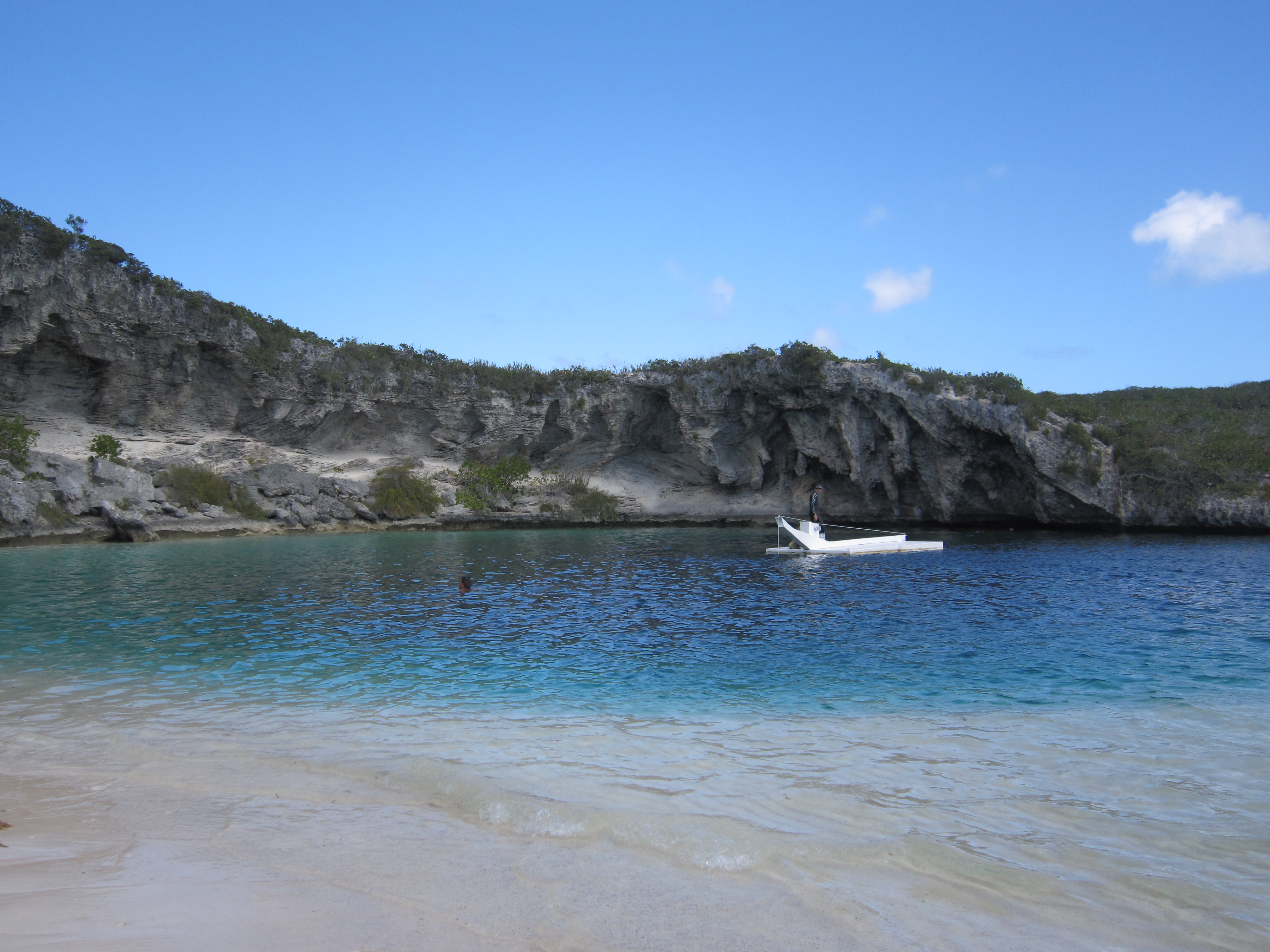
Sabrina and I walked the Current Island Settlement in the morning, it is a nice settlement with friendly people. It wouldn’t be a place I’d want to spend a week, but the nice sleepy town was a great place for a morning walk.  After we returned to the boat, we hauled anchor and proceeded to sail dead downwind under wing and wing with Moonshadow to an exposed wreck off the southern tip of Egg Island.  Along the way Bob and Judy on The Edge hailed us and I invited him to join us in our snorkeling adventure, they fell in line and the three of us proceeded to anchor near the wreck. The wreck was fantastic and for anyone snorkeling in Eleuthera it’s a ‘can’t miss’ destination.  I’ll be writing a full post on the wreck so hopefully google searchers will find the information and more people will experience this dive site. We also picked up two more large lionfish in the deeper water around the wreck.

After we jumped back onboard, Moonshadow and Joint Venture sailed over to Spanish Wells for the night.  Another dinner aboard, this time tandoori chicken, fresh naan, jasmine rice and Dark n’ Stormy’s celebrated another night with our friends.  We picked up mooring balls in the Spanish Wells harbor and watched in amazement as the big ferry moved through this tight channel.

Friday 17th – Spanish Wells to Gregory Town

We walked Spanish Wells with Glen and Seray on Friday morning.  It’s a nice town full of small working boats and big fishing boats. Spanish Wells supplies the majority of the lobster to the rest of the Bahamas, and it can be seen that tourism isn’t the number one enterprise in this town. For those wishing to buy seafood, this is not the place, lobster was $18/lb. We passed on lobster and took on diesel and water and wished Glen and Seray well on their sail to the Abacos.  I’m sure we’ll see them again this summer on the Bay.

From Spanish Wells we motored in light winds through Current Cut and on to Gregory Town.  Current Cut is not for the faint of heart, I had the boat in idle to try to slow our progress as we rocketed along at 8 knots.  We followed the preferred route in the guidebook to take a sharp angle to the south once we cleared the main cut and now the current was on our beam washing us towards the sand and rocks nearby.  While we made it through okay, I made a note on our chart to take the straight-away channel shown and disregard this curving channel.  It would also be best to approach either just before high tide or just after high tide so the current is less.  But we did have a great ride for awhile!

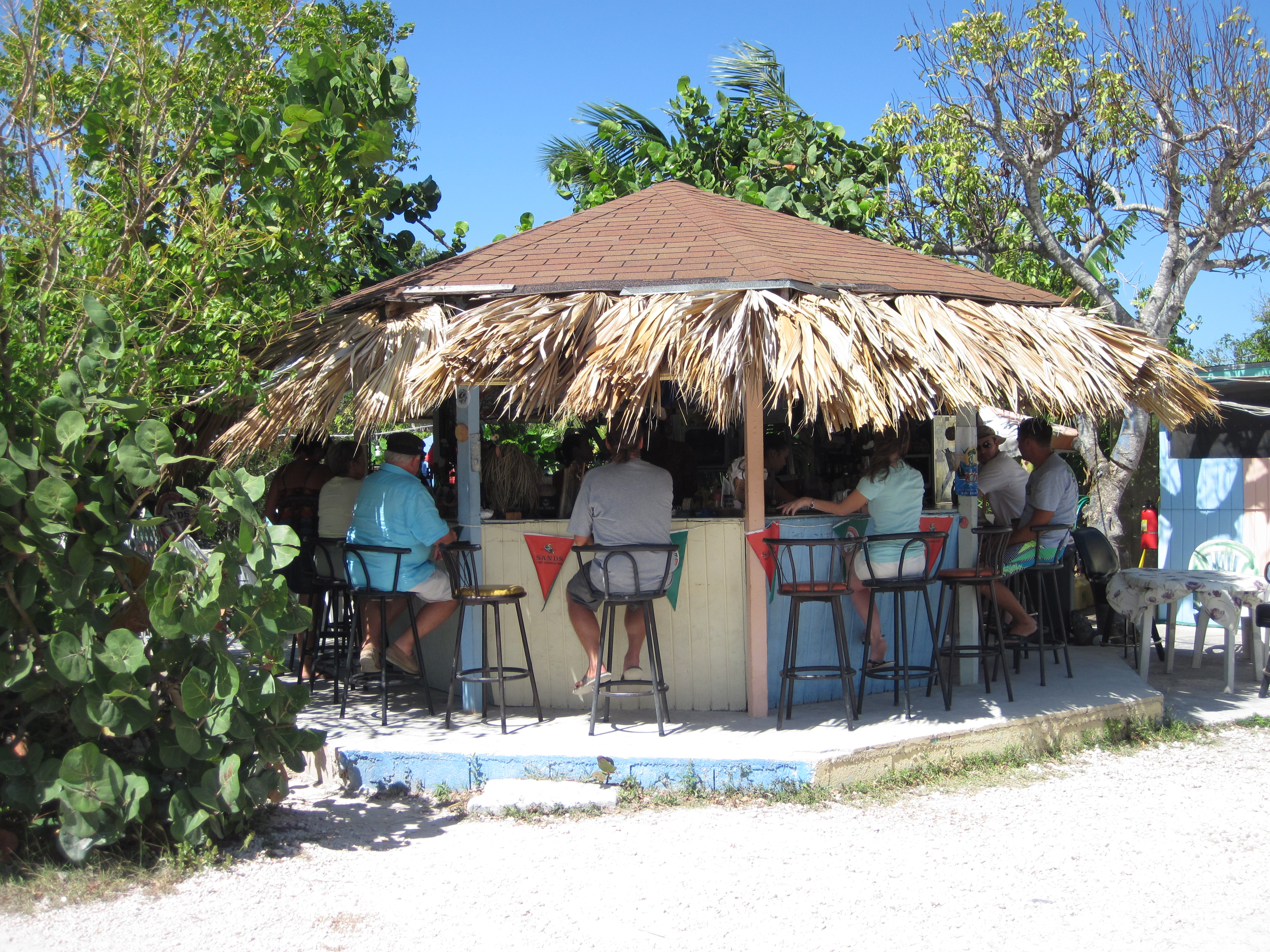
We went ashore in Gregory Town to find Elvina’s Restaurant and Laundromat which the guide book said had live music on Tuesday and Friday nights. Sadly we learned that Elvina passed away in the fall and the restaurant is closed. Other citizens are trying to reopen the restaurant, which was beloved by the residents, so other cruisers should check to see if it is open when they are passing through. Some residents directed us to a church fair that was benefitting new booths for the sanctuary of the Roman Catholic church in town.  We headed over to find fabulous food, friendly people, and Bahamian music blaring through the PA system. It was hard to hear the prices over the music, and I double-checked when I heard that their conch fritters were 6 for $1! Dinners were $10, Sabrina ordered the “Fry Fish” and I ordered the ribs.  The ribs were delicious, I could smell them being slow-cooked over the fresh coals that they were shoveling out of the large fire. Sabrina’s “Fry Fish” were two small fish, cleaned and lightly fried whole (i.e. bones, head, tail and all.) Sabrina said that they were good but I wouldn’t like them, so I took her word for it. J  Dinners came with the usual Bahamian sides – peas and rice, macaroni and cheese, and potato salad – along with a couple of beers apiece, and two orders of conch fritters, our big night out in Gregory Town cost us $32!  That’s the price of one dinner in Marsh Harbour!

Saturday 18th – Gregory Town to Hatchet Bay

Early in the morning we snorkeled some of the cliffs and large rocks found all along this stretch of Eleuthera.  We spotted a couple lobster, but the one I was able to flush out was small and the other one went deeper into the rocks. This whole stretch looked like a lobster’s paradise, and I assume that was the case, the deep cracks and holes in the rock probably hid them out of our sight.  We shot another lionfish and Sabrina cleaned this one by herself for her lunch.

Gregory Town is known as a surfer’s hangout and after snorkeling we went into town to photograph the sites and some of the local character. Several small boats were pulling in with hundreds of conch and cleaning them along the harbor walls. I think they see a lot of travelers via the Queen’s Highway which passes through town, but folks were a little surprised when we said we came in by boat. From Gregory Town we motored in light winds to the protected harbor of Hatchet Bay, nearby Alice Town’s motto is “Home of the Country’s Safest Harbor” and it’s easy to see why. The entrance was carved out of solid rock to the pond behind and is only 90 feet wide in the channel.  Once inside it opens up to a well-protected harbor and the anchoring is reportedly tricky, but there are ten free (yes, free) mooring balls.  We picked up the last mooring ball and I dinghied over to our neighbor to ensure that they were indeed free.  Once we were secure we headed into explore Alice Town.  It’s a friendly place and a bit bigger when compared to the quaint Gregory Town.

While in Alice Town we found the newly opened Twin Brother’s Seafood and Steakhouse. They said they had live music starting at 7 so we headed back to the boat for a bit and then dinghied back into town. The Twin Brother’s have had a daiquiri stand for a long time and the sign on the old stand says they were featured on NBC’s Top Chef and the New York Times. The restaurant just opened in December and one of the brother’s said they were still making changes to the layout of the bar and dining areas. We figured we needed to try a daiquiri, so Sabrina got mango and I got the “Miami Vice,” (a mixture of strawberry and pina colada,) and a dozen conch fritters. We can both say that these were the best daiquiris we’ve ever had.  They come without alcohol, and I suggest you don’t get the rum added, it just detracted from my drink.  The conch fritters were excellent and fried to perfection.

To anyone that wishes to dispute that Twin Brother’s has the best daiquiri in the world, I invite you to sail or fly to Eleuthera and see for yourself!

All in all, our two drinks, conch fritters, and live music cost us $17.25! I think we’re going to like getting away from the over-priced touristy locales.

And finally….. Today, Sunday the 19th

We’re riding out a mild frontal passage here in Hatchet Bay on our free mooring. Tomorrow morning we need to get an early start because there’s wind tomorrow but not much the rest of the week.  We’re trying to make it to Rock Sound and maybe even farther depending on what the weather does. We’ve working on some small projects on the boat and then stowing for the trip.

Who knows, maybe we’ll end up back at Twin Brother’s for another daiquiri tonight?

Categories: Uncategorized | 12 Comments

Heading South

Like I’ve said, many cruisers define cruising as ‘fixing your boat in exotic places,’ and that’s exactly what we’ve been doing for the last couple of days here at the Jib Room. But now things are running good and we’re ready to head out today to keep moving south.

We’re going to move the boat down to Lynyard Cay today so we can hopefully get an early start tomorrow.  We’re trying to make the jump from the Abacos to Eleuthera and points further south, we’ll be watching the weather because it’s a little shifty right now, but we should have great wind for sailing. It’s about a 10 hour trip to Eleuthera, and we want to arrive in daylight, so we need to leave early in the day.

Follow along on our Spot, we’ll be sure to have it on and tracking our progress.  If you see any large deviations in the track, it just means that I’m fishing!

We’ll post when we have internet in Eleuthera, if you need to contact us, text or leave a voicemail on the satellite phone, we’ll check it daily.

Categories: Uncategorized | 9 Comments

Life is like a box of chocolates…

Admittedly, Sabrina and I are somewhat “Forrest Gump-ing” our way through the Abacos.  We had few plans before we left the states (we didn’t have time to make plans in the craziness) and while the information in the guide books will get you started, it doesn’t tell you about the truly cool stuff.  We’ve lucked into great experiences from information provided by the kindness of other cruisers, and just being in the right place at the right time.  Some of our better days include Ann drawing maps in the sand on Manjack, seeing the Abaco Parrot and joining the BNT, finding blue holes in the Bight of Old Robinson, and most recently, attending a casting at the famous Johnston Studio in Little Harbour.

The approach into Little Harbour only has 3.5 feet of depth at low tide, our boat draws a little over 5 feet and the current tide state in the Bahamas is a little over 2 feet. So, if you do the math, we had to enter the harbor at almost high tide, and we only had about 6 inches to spare! We had debated for over a week about when to head into Little Harbour, and we had no real reason for going in on Wednesday afternoon. But we headed in, grabbed a mooring, toured the gallery, the foundry, and Pete’s Pub and then dinghied out to the Bight of Old Robinson to check out the blue holes.

On Thursday morning, we were debating what to do and we heard on the Cruiser’s Net that there would be a casting that day at the foundry. By sheer luck, we found ourselves already in the harbor, and quickly headed to shore to find out more.  We learned the casting would be at 12:30 or so and we were invited to stop back around then.  The high tide wasn’t until 3:45 so we wouldn’t have been able to get in if we had tried to on Thursday morning.

The Johnston Studio and Gallery is a famous attraction here in the Abacos.  Back in the 1950’s, Smith College professor and noted sculptor Randolph Johnston packed up his wife and three children into their sailboat and sailed to the islands to escape civilization and pursue his art.  They settled in Little Harbour and the Johnston family reportedly lived in caves and thatched huts they built until they were able to build a house and a foundry for Johnston’s art.  We took the dinghy to one of these caves and wondered about what is was like to reside, even temporarily, in the rocky interior. Randolph Johnston lived in Little Harbour until his death in 1992, and his son Pete, also a sculptor, owns “Pete’s Pub” and now runs the foundry and a gallery that displays and sells art from the studio.

We headed back into the foundry around noon because we didn’t want to miss the casting. The foundry uses the ancient “lost wax process” to cast sculptures out of bronze. I was relatively ignorant of the concept but the foundry director Richard was very patient, provided us information on the process and then took us on a tour of the studio. Richard (he’s French, so it’s pronounced Ree-shard) obviously very much enjoyed his job, he was charismatic, enthusiastic, and delighted to show us the various steps, I’ve outlined the process briefly here:

  1. Sculpt something out of clay or wax – bust, turtle, etc.
    This is the really artistic part, and I was amazed by Pete’s “originals” laying around the studio
  2. Cover this clay or wax in plaster or rubber and make a mold
  3. Remove the clay “original” and set it aside
  4. Fill the plaster mold with wax
  5. Pull the wax out, inspect it, and fix any imperfections – basically carve the sculpture again
  6. Coat the wax in a mixture of silica and paste, and dip it repeatedly, like you’re making a candle, to make a hard ceramic mold
  7. Melt the wax out of the ceramic mold with a blast furnace at 1400 degrees Fahrenheit
  8. Heat your bronze to 2100 degrees Fahrenheit
  9. Pour this molten metal into your preheated ceramic mold
  10. Let it cool, crack off the hard ceramic mold
  11. Polish, sand, or grind out any imperfections to your bronze casting
  12. To make another casting of the same original sculpture, start back at Step 3

This is a very basic outline, and listening to Richard explain about the various gates (funnels to allow the bronze to enter the mold,) vents to allow the air to escape, and how they have to manage weight by providing cavities in the sculptures was very fascinating.  He explained that bells use a different metal ratio for the bronze so that they are stronger, and showed some of the results they achieve with different chemicals to provide a patina, greening, or a shiny finish to the bronze.

Richard also explained that the “lost wax process” is the oldest known form of metal casting. One of the oldest known pieces is “Dancing Girl” and dates back 4,500 years. This process is also used to produce industrial parts, and NASA used it to cast pieces for the shuttle.

While the sculpting of the originals was light years beyond my poor artistic ability, the rest of the process appealed to the engineer in me. I was fascinated by all the variables they had to manage in this foundry located on a sand road in the middle of nowhere.  Not to mention the bubbling cauldron of liquid metal and the layers of protecting clothes they donned to work with it.

The last step before the bronze is ready was to have Richard toss wine bottles into the metal.  The glass melts quickly and attracts the impurities in the metal. He scoops it off and discards it before they begin to pour.  I suspect that Richard tries to use bottles from nice French wines for this step. It was exhilarating to watch them lift the crucible and begin to pour.  The heat is intense, even standing across the room, and I couldn’t imagine what would happen if they spilled.  Their protective clothing only does so much, Richard suffered a burn on his hand, and explained that dealing with the kiln where they pre-heat the ceramic molds is worse than the molten metal because he has to reach into the kiln to pull the pieces out by hand (remember it’s 1,400 degrees Fahrenheit.) After they finished pouring, the pieces were still glowing red hot until we left about 15 minutes later, and I don’t know how long it is until they can safely be handled.

Richard explained that every time they do a casting it costs $1,000.  Therefore they only do castings when they need items in the store.  Some years he said they had done 35 castings, but recently with the economy they’ve had as few as 8 castings.  He said they’ve recently sold some pieces of Pete’s that depict various scenes from “The Old Man and the Sea.” They like to keep the full series in the gallery and that’s one of the reasons they decided to cast on Thursday.

Regardless of the reason for the casting, we felt very fortunate to witness something so strange in this tiny, little, remote corner of the earth. I guess Mr. Gump was right, “…you never know what you’re gonna get.”

Categories: Uncategorized | 2 Comments

We found a blue hole!

And it is visible from space!

Click this link:  Blue Hole

Then switch to the satellite view and zoom in, you’ll see the blue hole that we were floating above in the dinghy. For more on the blue holes, check out this informative website:  http://www.abacoescape.com/BlueHole.html. The blue hole we found is marked by a somber reminder on shore:

Memorial Plaque

I’ve transcribed it for those that can’t read it:

IN MEMORIAM
-Jason A. Hensley
-Mathew C. Fidler
-Ryan C. Smith
drowned here on 2 April 1994
Let this be a forewarning to any who would endeavor to explore these tunnels below.

This is the main danger with blue holes, some people will explore them with scuba equipment, you can get lost, disoriented or run out of air within the labyrinth of caves beneath the surface.  In the future, Sabrina and I may snorkel around these holes, which is considered safe, but we will never dive them without the proper training and a guide.

The blue holes are difficult to see unless the light is right,here’s a photo looking out across the hole:

Blue Hole from the Surface

But once you near the hole, there is no mistaking it, the bottom will drop from 3-5′ of sand and grass to a great abyss of limestone and deep blue water, it’s easy to see why people become enchanted with these curious geological formations.

We were up early again to listen to the weather forecast, and now we have a big day planned in Little Harbor.  We’ll let you know more about our stay tomorrow.

Sunrise Little Harbor

Categories: Uncategorized | 1 Comment

Yo ho ho!

Yesterday on the Cruiser’s Net a boat requested GPS coordinates for the blue holes within the Bight of Old Robinson. These blue holes are infamous and somewhat undiscovered, so I was surprised when someone actually answered this request.  We quickly jumped on the radio and provided our email address to get the coordinates emailed to us.

When the email arrived, I was amazed, there was a map and coordinates provided to 7 of the reported 14 blue holes. I hesitate to post the pdf, but if you’re interested in seeing it, just email me.  The nice cruisers that provided the map simply asked that if we locate one of the undiscovered blue holes that we forward them the coordinates.

When I looked at the map, I sensed we were ready for an adventure. Admittedly, I just read Treasure Island (free on my Kindle) so my mind immediately ran to Long John Silver and Jim searching about for Captain Flint’s buried treasure. We’ve decided to hold a “treasure hunt” this afternoon and tomorrow afternoon at high tide.  We’re going to first try to find the 7 holes with coordinates and then locate some of the uncharted holes.

Here’s how you can follow along, we’ll be carrying our Spot tracker with us as we travel the Bight of Old Robinson.  We’ll leave the tracker on so you can see where we are, and if we actually locate a blue hole we’ll hit our custom message button to let you know.  If you’re interested in this, simply check in periodically on our Where are we? page.  We’ll post pictures when we return.

High tide is around 3:00 p.m. on both days, so check out that page in the afternoon if you’re interested, consider it a webventure!

Categories: Uncategorized | 3 Comments